Fitur bawah laut · Rekahan erupsi
Unnamed submarine volcano in the eastern Pacific Ocean
Northern EPR at 9.8°N
- Tipe
- Rekahan erupsi
- Ketinggian
- 2500 m (bawah laut)
- Letusan terakhir
- 2025
- Tipe
- Rekahan erupsi
- Negara
- Fitur bawah laut
- Wilayah
- Pasifik Timur / Northern East Pacific Rise Volcanic Province
- Ketinggian
- 2500 m (bawah laut)
- Koordinat
- 9.830, -104.300
- Letusan terakhir
- 2025
- Kondisi tektonik
- Zona rift / Kerak samudra (< 15 km)
- Bentuk lahan
- Gugusan gunung api
- Batuan utama
- Basal / Pikrobasal
Ringkasan geologi
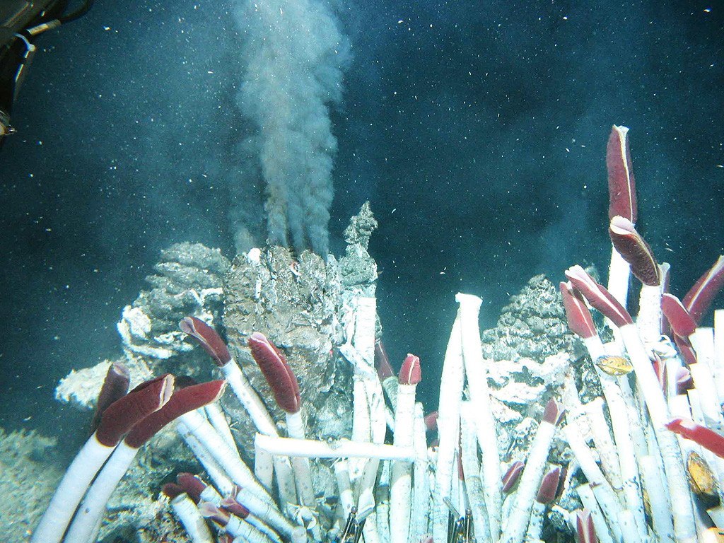
A series of dives with the submersible Alvin in 1991 on the East Pacific Rise at about 9°50'N detected evidence for a very recent, possibly ongoing, eruption. Hot-vent animal communities documented during November-December 1989 had been buried by fresh basaltic lava flows, and the scorched soft tissues of partially buried biota had not yet attracted bottom scavengers. Fresh black smoker chimneys and new lava flows were present. This site is south of the Clipperton Fracture Zone at a depth of about 2,500 m, and about 1,000 km SW of Acapulco, México; the south end of the Lamont Seamount chain is about 10 km NW. This is also the location where lava flows previously estimated as being less than roughly 50 years old had been found. Later dating using very short half-life radionuclides from dredged samples confirmed the young age of the eruption and indicated that another eruptive event had taken place in late 1991 and early 1992. An eruption in 2005-2006 produced lava flows that entrapped previously emplaced seismometers.
Riwayat letusan
18 tercatatGlosariumGaris waktu rinci
- 2025VEI 0Teramati2025-04-28 – 2025-04-29Tica hydrothermal vent, 9°50’N (9.83°N)
- 2005VEI 0Teramati2005-08-16 – 2006-01-16East Pacific Rise (9.8°N)
- 1991VEI 0Perkiraan geologi1991-01-27 – 1991-03-26East Pacific Rise (9.84°N)
- 1991VEI 0Perkiraan geologi1991-12-01 – 1992-02-05East Pacific Rise (9.84°N)
- 1988VEI 0Teramati1988-07-02 – akhir tidak diketahuiEast Pacific Rise (9.27°N)
- 1950VEI 0Perkiraan geologi1950-07-02 – akhir tidak diketahuiEast Pacific Rise (9.87°N)
- 1875VEI 0Perkiraan geologi1875-07-02 – akhir tidak diketahuiEast Pacific Rise (9.9°N)
- 1650 (±100 tahun)VEI 0Perkiraan geologi1650 – akhir tidak diketahuiEast Pacific Rise (9.82°N)
- 1600 (±150 tahun)VEI 0Perkiraan geologi1600 – akhir tidak diketahuiEast Pacific Rise (9.87°N)
- 1200 (±300 tahun)VEI 0Perkiraan geologi1200 – akhir tidak diketahuiEast Pacific Rise (9.82°N)
- 950 (±2000 tahun)VEI 0Perkiraan geologi950 – akhir tidak diketahuiEast Pacific Rise (9.5°N)
- 850 (±200 tahun)VEI 0Perkiraan geologi850 – akhir tidak diketahuiEast Pacific Rise (9.87°N)
- 50 SM (±2000 tahun)VEI 0Perkiraan geologi50 SM – akhir tidak diketahuiEast Pacific Rise (9.5°N)
- 1050 SM (±2000 tahun)VEI 0Perkiraan geologi1050 SM – akhir tidak diketahuiEast Pacific Rise (9.5°N)
- 2050 SM (±2000 tahun)VEI 0Perkiraan geologi2050 SM – akhir tidak diketahuiEast Pacific Rise (9.5°N)
- 3050 SM (±2000 tahun)VEI 0Perkiraan geologi3050 SM – akhir tidak diketahuiEPR axis and East of axis
- 4050 SM (±2000 tahun)VEI 0Perkiraan geologi4050 SM – akhir tidak diketahuiEast Pacific Rise (9.5°N)
- 5050 SM (±8000 tahun)VEI 0Perkiraan geologi5050 SM – akhir tidak diketahuiEPR axis and East and West of axis
Gunung api terdekat
- Unnamed submarine volcano in the Pacific OceanRekahan erupsi · sejauh 127 km
- Northern EPR-Segment RO3Rekahan erupsi · sejauh 678 km
- Northern EPR-Segment RO2Rekahan erupsi · sejauh 755 km
- Gunung ColimaStratovolkan · sejauh 1079 km
- Nevado de TolucaStratovolkan · sejauh 1141 km
- ParicutínMedan gunung api · sejauh 1147 km
Tautan eksternal
- Belum ada di Wikipedia (Bahasa Indonesia). Anda dapat berkontribusi di Wikidata.
- Halaman asli Smithsonian GVP
⚠ Untuk referensi saja. Bukan untuk tanggap darurat.