본문으로 건너뛰기

미국 · 열극 분화구

Escanaba Segment

화산 유형
열극 분화구
해발
1700m (해저)
마지막 분화
-2260년
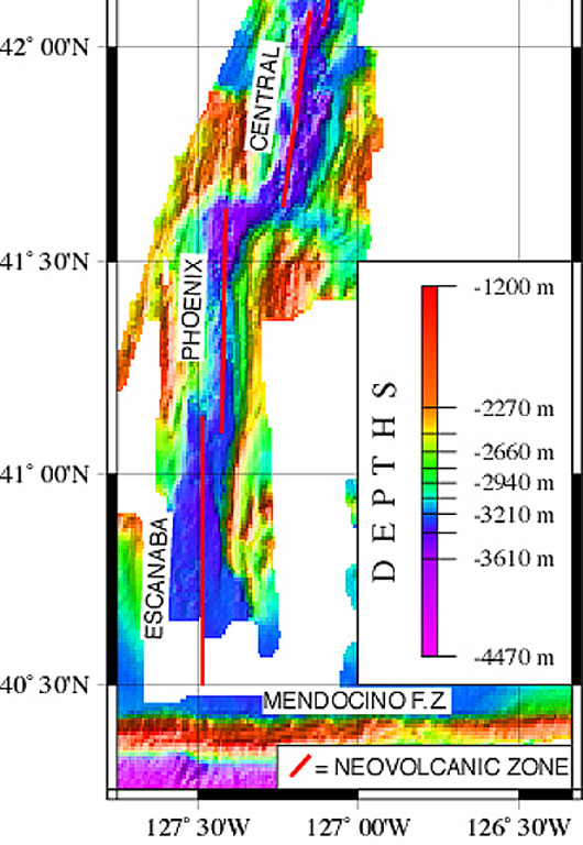
A NOAA/PMEL map shows the setting of the Escanaba Segment at the southern end of the Gorda Ridge west of the coast of northern California. The linear N-S-trending segment is the southernmost of the five segments of the Gorda Ridge, and lies immediately north of the Mendocino Fracture Zone. The axial crest of the 130-km-long segment, also known as the Escanaba Trough, is about 3-5 km wide at the northern end and widens to 18 km in the south near the junction with the Mendocino Fracture Zone.
A NOAA/PMEL map shows the setting of the Escanaba Segment at the southern end of the Gorda Ridge west of the coast of northern California. The linear N-S-trending segment is the southernmost of the five segments of the Gorda Ridge, and lies immediately north of the Mendocino Fracture Zone. The axial crest of the 130-km-long segment, also known as the Escanaba Trough, is about 3-5 km wide at the northern end and widens to 18 km in the south near the junction with the Mendocino Fracture Zone. · 사진: Courtesy of NOAA NeMo Observatory.
화산 유형
열극 분화구
국가
미국
지역
동태평양 / Northeast Pacific Rifts Volcanic Province
해발
1700m (해저)
좌표
40.980, -127.500
마지막 분화
-2260년
판구조 환경
열곡대 / 해양 지각 (< 15 km)
화산 지형
화산군
주요 암석
현무암 / 피크로현무암

지질학적 요약

영어 원문

The linear, N-S-trending Escanaba Segment, the southernmost of the Gorda Ridge, lies immediately north of the Mendocino Fracture Zone off the coast of northern California.

출처: Global Volcanism Program, Smithsonian Institution (발췌) · GVP에서 전체 요약 읽기 →

분화 이력

1건 기록용어집

기록 요약

확인된 분화
1건
불확실한 분화
0건
확인된 기록 범위
기원전 2260년 ~ 기원전 2260년
가장 큰 확인된 분화
VEI 0 (기원전 2260년)
1900년 이후 확인된 분화
0건
요약 (VEI 시계열)
막대를 클릭하면 개별 분화가 표시됩니다 · 화살표 키로 막대 이동, Enter로 열기
기원전 2260~기원전 2260 · 1건 · 최고 VEI 0기원전 2260기원전 2260기원전 2259기원전 2259기원전 2259

상세 타임라인

  1. 기원전 2260년VEI 0지질학적 추정
    기원전 2260 ~ 종료일 미상
    40 deg 59 min North

주변 화산

외부 링크

⚠ 참고용 정보입니다. 재난 대응에 사용하지 마세요.