Kenia · Volcán en escudo
Barrier (volcán)
Barrier, The
- Tipo
- Volcán en escudo
- Altitud
- 1032 m
- Última erupción
- 1921
- Tipo
- Volcán en escudo
- País
- Kenia
- Región
- África Oriental / Kenyan Rift Volcanic Province
- Altitud
- 1032 m
- Coordenadas
- 2.320, 36.570
- Última erupción
- 1921
- Contexto tectónico
- Zona de rift / Corteza continental (> 25 km)
- Forma volcánica
- Escudo
- Roca principal
- Traquita / Traquidacita
Resumen geológico
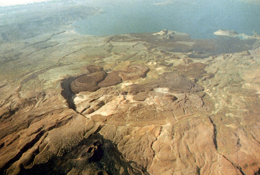
The Barrier volcanic complex separates Lake Turkana from the broad Suguta Trough to the S, the site of a former lake. The volcano is comprised of four overlapping shield volcanoes, with the youngest, Kakorinya, located over the axis of the East African Rift. Kalolenyang volcano lies W of Kakorinya, and Likaiu West and Likaiu East are located to the ENE. A 3.8-km-wide summit caldera was formed at Kakorinya about 92,000 years ago. Youthful-looking trachytic and phonolitic lava domes and flows erupted within the caldera and along its ring fracture fill much of the caldera floor. Early Holocene fissure-related scoria cones and lava flows dot the S and N flanks. Solfataric fields are located within the caldera and on the W and S flanks. Historical eruptions from Teleki's and Andrew's cones on the N and S flanks, respectively, have produced basaltic explosive activity and lava flows during the 19th and 20th centuries.
Resumen de Wikipedia
El Barrier es un volcán en escudo del Valle Suguta. Recibe su nombre porque forma una barrera de unos 20 km separando el valle del Suguta del lago Turkana.
Wikipedia · CC BY-SA · Leer artículo completo →
Historial de erupciones
12 registradasGlosarioLínea de tiempo detallada
- 1921VEI 2Observado1921-12-31 – fin desconocidoNorth flank (Teleki)
- 1920 (±3 años)VEI ?Método no indicado1920-07-02 – fin desconocidoSouth flank (Andrew's Volcano)
- 1917VEI 2Observado1917-07-02 – fin desconocidoAndrew's or Teleki's Volcanoes
- 1906VEI ?Método no indicado1906-07-02 – fin desconocidoAndrew's or Teleki's Cones
- 1897VEI 2Observado1897-05-16 – fin desconocidoNorth flank (Teleki) and Likaiu
- 1895VEI 2Observado1895-07-02 – fin desconocidoNorth flank (Teleki's Cone)
- 1888VEI 0Observado1888-07-02 – fin desconocidoNorth flank (Teleki's Cone)
- 1871 (±3 años)VEI 2Observado1871-07-02 – fin desconocidoNorth flank (Teleki's Cone)
- 1090 (±50 años)VEI 0Estimación geológica1090 – fin desconocidoNorth flank
- 1050 (±150 años)VEI 0Estimación geológica1050 – fin desconocidoNorth flank
- 1030 (±150 años)VEI 0Estimación geológica1030 – fin desconocidoNorth flank
- 7710 a. C. (±200 años)VEI ?Estimación geológica7710 a. C. – fin desconocidoNorth (Abili Agituk) and south flanks
Volcanes cercanos
Enlaces externos
⚠ Solo como referencia. No apto para respuesta ante emergencias.