Stati Uniti · Frattura eruttiva
Escanaba Segment
- Tipo
- Frattura eruttiva
- Altitudine
- 1700 m (sottomarino)
- Ultima eruzione
- -2260
- Tipo
- Frattura eruttiva
- Paese
- Stati Uniti
- Regione
- Pacifico orientale / Northeast Pacific Rifts Volcanic Province
- Altitudine
- 1700 m (sottomarino)
- Coordinate
- 40.980, -127.500
- Ultima eruzione
- -2260
- Contesto tettonico
- Zona di rift / Crosta oceanica (< 15 km)
- Forma vulcanica
- Gruppo vulcanico
- Roccia principale
- Basalto / Picrobasalto
Sintesi geologica
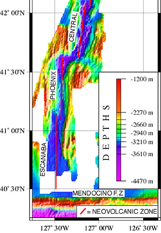
The linear, N-S-trending Escanaba Segment, the southernmost of the Gorda Ridge, lies immediately north of the Mendocino Fracture Zone off the coast of northern California. The axial crest of the 130-km-long segment, also known as the Escanaba Trough, is about 3-5 km wide at the northern end and increases to 18 km to the south near the junction with the Mendocino FZ. The rift valley floor of the slow-spreading segment lies at about 3,200 m depth, bounded by faulted walls about 1,500 m high with unusual gold-bearing massive sulfide deposits in sediment hills at the base of the scarps uplifted by volcanic sills or laccoliths. Thick sediment deposits from the continental margin enter the axial trough from the fracture zone and thin to the north. A preliminary uranium-series date of Holocene age was obtained from a basaltic lava flow in the axial valley in the less-sedimented northern part.
Storia delle eruzioni
1 registrateGlossarioCronologia dettagliata
- 2260 a.C.VEI 0Stima geologica2260 a.C. – fine sconosciuta40 deg 59 min North
Vulcani nelle vicinanze
Link esterni
- Non ancora su Wikipedia (Italiano). Puoi contribuire su Wikidata.
- Pagina originale Smithsonian GVP
⚠ Solo a scopo informativo. Non adatto a situazioni di emergenza.