Vai al contenuto principale

Formazioni sottomarine · Frattura eruttiva

East Gakkel Ridge at 85 E

East Gakkel Ridge at 85°E

Tipo
Frattura eruttiva
Altitudine
3800 m (sottomarino)
Ultima eruzione
1999
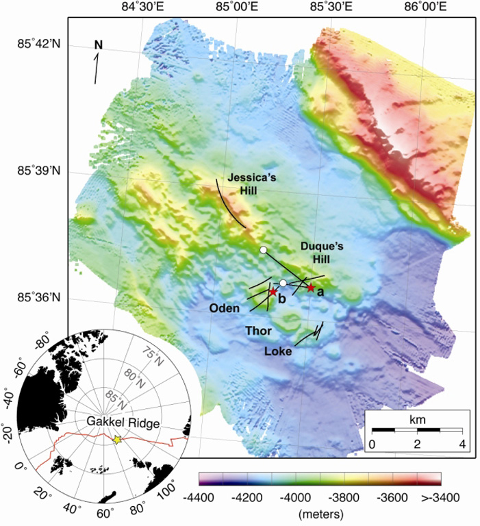
Detailed bathymetry of the East Gakkel Ridge at 85°E in the Arctic Ocean. The inset map shows the location of the 85°E segment (yellow star) along the Gakkel Ridge (red line). The main panel shows illuminated color bathymetry (30-m grid spacing) of the 85°E segment acquired during the AGAVE expedition. The axial valley contains large numbers of distinctive, cratered volcanoes, including a cone on a fault terrace of the northern valley wall. Named features include two volcanic ridges in the center of the axial valley (Jessica’s Hill and Duque’s Hill), and three cratered volcanoes along a ridge-parallel fissure to the south (Oden, Thor, and Loke). The bathymetry data were plotted with Generic Mapping Tools.
Detailed bathymetry of the East Gakkel Ridge at 85°E in the Arctic Ocean. The inset map shows the location of the 85°E segment (yellow star) along the Gakkel Ridge (red line). The main panel shows illuminated color bathymetry (30-m grid spacing) of the 85°E segment acquired during the AGAVE expedition. The axial valley contains large numbers of distinctive, cratered volcanoes, including a cone on a fault terrace of the northern valley wall. Named features include two volcanic ridges in the center of the axial valley (Jessica’s Hill and Duque’s Hill), and three cratered volcanoes along a ridge-parallel fissure to the south (Oden, Thor, and Loke). The bathymetry data were plotted with Generic Mapping Tools. · Foto: Sohn et al., 2008. Explosive volcanism on the ultraslow-spreading Gakkel ridge, Arctic Ocean. Nature, v. 453, p. 1236-1238.
Tipo
Frattura eruttiva
Paese
Formazioni sottomarine
Regione
Oceano Atlantico / Arctic Ridge Volcanic Province
Altitudine
3800 m (sottomarino)
Coordinate
85.608, 85.250
Ultima eruzione
1999
Contesto tettonico
Zona di rift / Crosta oceanica (< 15 km)
Forma vulcanica
Gruppo vulcanico
Roccia principale
Nessun dato
Sintesi geologica

During January-September 1999 global seismic networks detected an earthquake swarm along the East Gakkel Ridge (near 86°N, 85°E). Sonar mapping in May 1999 identified a cone at the western end of a line of volcanoes that corresponded to the average location of the epicenters (Edwards et al., 2001). A survey in July 2007 (Sohn et al., 2008) provided detailed bathymetry and named selected features, including the Oden (location of the 1999 seismicity), Thor, and Loke cones. Both Oden and Loke were covered with a light dusting of pyroclastic material, which was also found throughout the survey area, thought to be products of an eruption during the 1999 swarm.

Storia delle eruzioni

1 registrateGlossario
Riepilogo (VEI nel tempo)
Fai clic su una barra per vedere le singole eruzioni · Usa le frecce per spostarti tra le barre, Invio per aprire
1999~1999 · 1 eruzioni · VEI max. 219991999200020002000

Cronologia dettagliata

  1. 1999VEI 2Osservata
    1999-04-05 – 1999-04-15
    East Gakkel Ridge

Vulcani nelle vicinanze

Link esterni

⚠ Solo a scopo informativo. Non adatto a situazioni di emergenza.