本文へスキップ
地図に戻る
比較地図で見る

インドネシア · 成層火山

イリラバレカン山

Ililabalekan

タイプ
成層火山
標高
1018m
最終噴火
不明
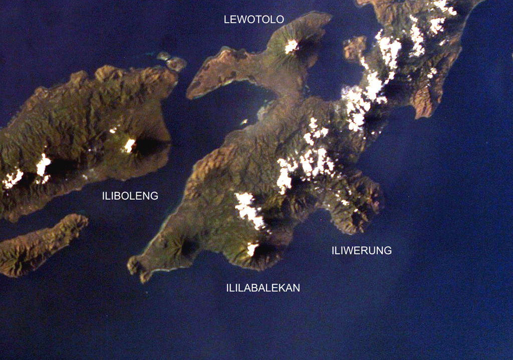
Four volcanoes are seen in this NASA International Space Station image (with north to the upper left) of Solor (lower left), Adonara (upper left), and Lembata (right) Islands.  Ililabalekan volcano on SW Lembata (formerly Lomblen) Island is the only one of these without historical eruptions, although fumaroles are found near its summit.  A satellitic cone was constructed on the SE flank of the steep-sided volcano, and four craters, one of which contains a lava dome and two small explosion pits, occur at the summit of Mount Labalekan.
Four volcanoes are seen in this NASA International Space Station image (with north to the upper left) of Solor (lower left), Adonara (upper left), and Lembata (right) Islands. Ililabalekan volcano on SW Lembata (formerly Lomblen) Island is the only one of these without historical eruptions, although fumaroles are found near its summit. A satellitic cone was constructed on the SE flank of the steep-sided volcano, and four craters, one of which contains a lava dome and two small explosion pits, occur at the summit of Mount Labalekan. · 写真: NASA International Space Station image ISS009-E-7480, 2004 (http://eol.jsc.nasa.gov/).
タイプ
成層火山
国
インドネシア
地域
スンダ・バンダ / Sunda Volcanic Arc
標高
1018m
座標
-8.550, 123.380
最終噴火
不明
テクトニクス環境
沈み込み帯 / 地殻の厚さ不明
火山地形
複成火山
主要岩石
玄武岩 / ピクライト質玄武岩
地質学的概要

Ililabalekan volcano is situated on a prominent peninsula in SW Lembata (formerly Lomblen) Island. A satellitic cone was constructed on the SE flank of the steep-sided volcano. Four craters, one of which contains a lava dome and two small explosion pits, occur at the summit of Mount Labalekan. No historical eruptions are known from the volcano, although fumaroles are found near its summit.

噴火履歴

用語集

詳細タイムライン

噴火記録はありません。

近くの火山

外部リンク

⚠ 参考情報です。緊急対応には使用しないでください。