본문으로 건너뛰기

뉴질랜드 · 성층화산

Rumble II West Seamount

Rumble II West

화산 유형
성층화산
해발
1200m (해저)
마지막 분화
미확인
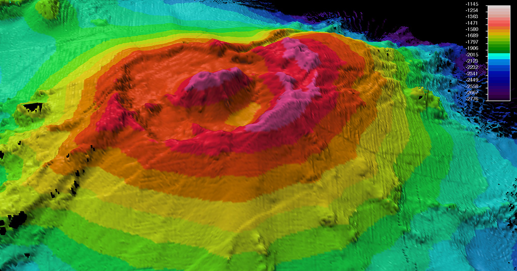
A bathymetric map was made during a 2009 voyage on the research vessel R/V Thompson of Rumble II West submarine volcano. Located NW of Rumble II East, Rumble II West, with a summit depth of 1,200 m, is the deepest of the Rumble group of seamounts, but displays evidence of hydrothermal activity. It contains a 2.5-3 km wide summit caldera about 200 m deep with a central cone. Recent lava flows originating from near the caldera rim with little or no sediment cover are on the S flanks.
A bathymetric map was made during a 2009 voyage on the research vessel R/V Thompson of Rumble II West submarine volcano. Located NW of Rumble II East, Rumble II West, with a summit depth of 1,200 m, is the deepest of the Rumble group of seamounts, but displays evidence of hydrothermal activity. It contains a 2.5-3 km wide summit caldera about 200 m deep with a central cone. Recent lava flows originating from near the caldera rim with little or no sediment cover are on the S flanks. · 사진: Photo courtesy of New Zealand Institute of Geology and Nuclear Sciences, 2009.
화산 유형
성층화산
국가
뉴질랜드
지역
통가·케르마덱 / Southern Kermadec Volcanic Arc
해발
1200m (해저)
좌표
-35.353, 178.527
마지막 분화
미확인
판구조 환경
섭입대 / 해양 지각 (< 15 km)
화산 지형
복성화산체
주요 암석
안산암 / 현무암질 안산암
지질학적 요약

Rumble II West, about 12 km NW of Rumble II East, rises 1,800 m from the ocean floor to within 1,200 m of the surface. Bathymetry shows a 2.5-3 km summit caldera about 200 m deep with a central cone. There is evidence of hydrothermal activity, and cones are present on the flanks. Some lava flows on the western flanks originating from near the caldera rim have little or no sediment cover.

분화 이력

용어집

상세 타임라인

분화 기록이 없습니다.

주변 화산

외부 링크

⚠ 참고용 정보입니다. 재난 대응에 사용하지 마세요.