Undersea features · Fissure vent

East Gakkel Ridge at 85 E

East Gakkel Ridge at 85°E

Type
Fissure vent
Elevation
3800m (submarine)
Last eruption
1999
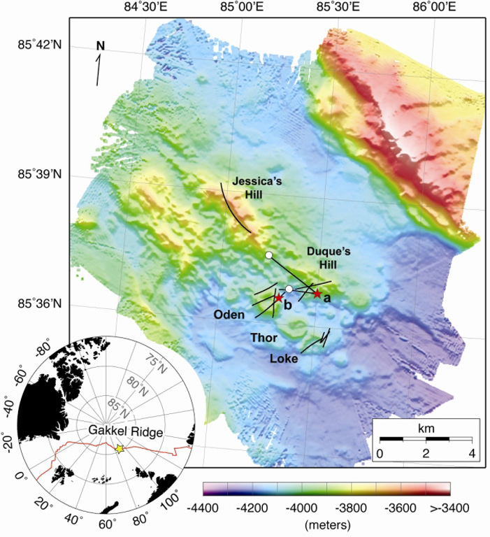
Detailed bathymetry of the East Gakkel Ridge at 85°E in the Arctic Ocean. The inset map shows the location of the 85°E segment (yellow star) along the Gakkel Ridge (red line). The main panel shows illuminated color bathymetry (30-m grid spacing) of the 85°E segment acquired during the AGAVE expedition. The axial valley contains large numbers of distinctive, cratered volcanoes, including a cone on a fault terrace of the northern valley wall. Named features include two volcanic ridges in the center of the axial valley (Jessica’s Hill and Duque’s Hill), and three cratered volcanoes along a ridge-parallel fissure to the south (Oden, Thor, and Loke). The bathymetry data were plotted with Generic Mapping Tools.
Detailed bathymetry of the East Gakkel Ridge at 85°E in the Arctic Ocean. The inset map shows the location of the 85°E segment (yellow star) along the Gakkel Ridge (red line). The main panel shows illuminated color bathymetry (30-m grid spacing) of the 85°E segment acquired during the AGAVE expedition. The axial valley contains large numbers of distinctive, cratered volcanoes, including a cone on a fault terrace of the northern valley wall. Named features include two volcanic ridges in the center of the axial valley (Jessica’s Hill and Duque’s Hill), and three cratered volcanoes along a ridge-parallel fissure to the south (Oden, Thor, and Loke). The bathymetry data were plotted with Generic Mapping Tools. · Photo: Sohn et al., 2008. Explosive volcanism on the ultraslow-spreading Gakkel ridge, Arctic Ocean. Nature, v. 453, p. 1236-1238.
Type
Fissure vent
Country
Undersea features
Region
Atlantic Ocean / Arctic Ridge Volcanic Province
Elevation
3800m (submarine)
Coordinates
85.608, 85.250
Last eruption
1999
Tectonic setting
Rift zone / Oceanic crust (< 15 km)
Landform
Cluster
Major rock type
No data

Geological summary

During January-September 1999 global seismic networks detected an earthquake swarm along the East Gakkel Ridge (near 86°N, 85°E).

Excerpt from the Global Volcanism Program, Smithsonian Institution · Read the full summary on GVP →

Eruption history

1 recordedGlossary

Record summary

Confirmed eruptions
1
Uncertain eruptions
0
Span of confirmed record
1999 – 1999
Largest confirmed eruption
VEI 2 (1999)
Confirmed eruptions since 1900
1
Summary (VEI over time)
Click a bar to see individual eruptions · Use arrow keys to move between bars, Enter to open
1999~1999 · 1 eruptions · max VEI 219991999200020002000

Detailed timeline

  1. 1999VEI 2Observed
    1999-04-05 – 1999-04-15
    East Gakkel Ridge

Nearby volcanoes

External links

⚠ For reference only. Not for emergency response.