Saltar al contenido principal

Formas submarinas · Fisura volcánica

East Gakkel Ridge at 85 E

East Gakkel Ridge at 85°E

Tipo
Fisura volcánica
Altitud
3800 m (submarino)
Última erupción
1999
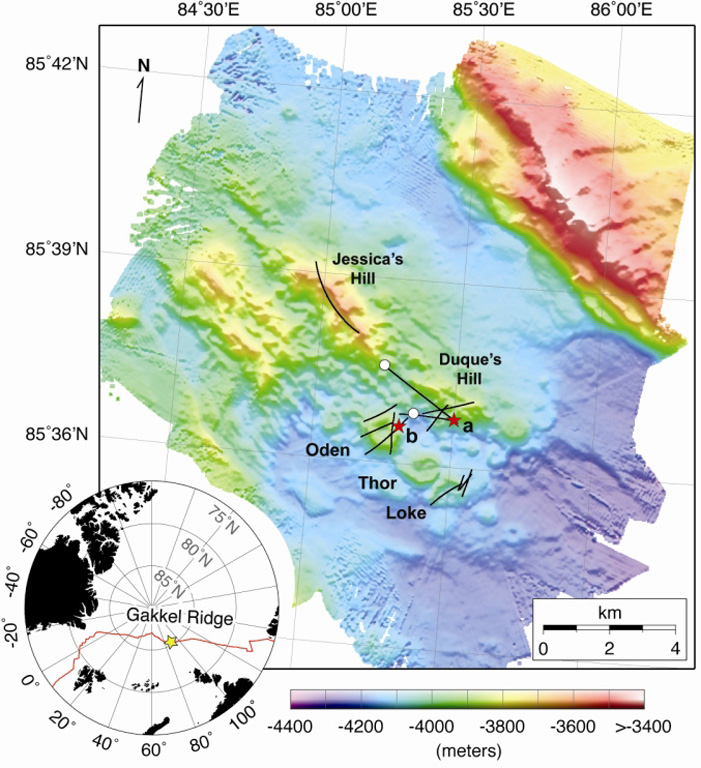
Detailed bathymetry of the East Gakkel Ridge at 85°E in the Arctic Ocean. The inset map shows the location of the 85°E segment (yellow star) along the Gakkel Ridge (red line). The main panel shows illuminated color bathymetry (30-m grid spacing) of the 85°E segment acquired during the AGAVE expedition. The axial valley contains large numbers of distinctive, cratered volcanoes, including a cone on a fault terrace of the northern valley wall. Named features include two volcanic ridges in the center of the axial valley (Jessica’s Hill and Duque’s Hill), and three cratered volcanoes along a ridge-parallel fissure to the south (Oden, Thor, and Loke). The bathymetry data were plotted with Generic Mapping Tools.
Detailed bathymetry of the East Gakkel Ridge at 85°E in the Arctic Ocean. The inset map shows the location of the 85°E segment (yellow star) along the Gakkel Ridge (red line). The main panel shows illuminated color bathymetry (30-m grid spacing) of the 85°E segment acquired during the AGAVE expedition. The axial valley contains large numbers of distinctive, cratered volcanoes, including a cone on a fault terrace of the northern valley wall. Named features include two volcanic ridges in the center of the axial valley (Jessica’s Hill and Duque’s Hill), and three cratered volcanoes along a ridge-parallel fissure to the south (Oden, Thor, and Loke). The bathymetry data were plotted with Generic Mapping Tools. · Foto: Sohn et al., 2008. Explosive volcanism on the ultraslow-spreading Gakkel ridge, Arctic Ocean. Nature, v. 453, p. 1236-1238.
Tipo
Fisura volcánica
País
Formas submarinas
Región
Océano Atlántico / Arctic Ridge Volcanic Province
Altitud
3800 m (submarino)
Coordenadas
85.608, 85.250
Última erupción
1999
Contexto tectónico
Zona de rift / Corteza oceánica (< 15 km)
Forma volcánica
Grupo volcánico
Roca principal
Sin datos

Resumen geológico

Original en inglés

During January-September 1999 global seismic networks detected an earthquake swarm along the East Gakkel Ridge (near 86°N, 85°E).

Extracto del Global Volcanism Program, Smithsonian Institution · Leer el resumen completo en el GVP →

Historial de erupciones

1 registradasGlosario

Resumen del registro

Erupciones confirmadas
1
Erupciones inciertas
0
Período del registro confirmado
1999 – 1999
Mayor erupción confirmada
VEI 2 (1999)
Erupciones confirmadas desde 1900
1
Resumen (VEI en el tiempo)
Haga clic en una barra para ver erupciones individuales · Usa las flechas para moverte entre barras y Enter para abrir
1999~1999 · 1 erupciones · VEI máx. 219991999200020002000

Línea de tiempo detallada

  1. 1999VEI 2Observado
    1999-04-05 – 1999-04-15
    East Gakkel Ridge

Volcanes cercanos

Enlaces externos

⚠ Solo como referencia. No apto para respuesta ante emergencias.