Lewati ke konten utama

Fitur bawah laut · Rekahan erupsi

East Gakkel Ridge at 85 E

East Gakkel Ridge at 85°E

Tipe
Rekahan erupsi
Ketinggian
3800 m (bawah laut)
Letusan terakhir
1999
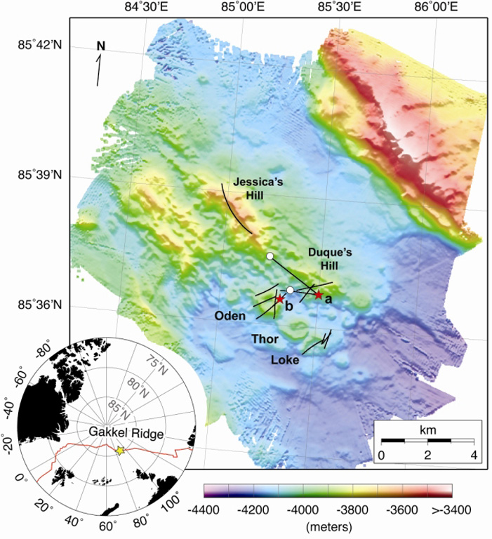
Detailed bathymetry of the East Gakkel Ridge at 85°E in the Arctic Ocean. The inset map shows the location of the 85°E segment (yellow star) along the Gakkel Ridge (red line). The main panel shows illuminated color bathymetry (30-m grid spacing) of the 85°E segment acquired during the AGAVE expedition. The axial valley contains large numbers of distinctive, cratered volcanoes, including a cone on a fault terrace of the northern valley wall. Named features include two volcanic ridges in the center of the axial valley (Jessica’s Hill and Duque’s Hill), and three cratered volcanoes along a ridge-parallel fissure to the south (Oden, Thor, and Loke). The bathymetry data were plotted with Generic Mapping Tools.
Detailed bathymetry of the East Gakkel Ridge at 85°E in the Arctic Ocean. The inset map shows the location of the 85°E segment (yellow star) along the Gakkel Ridge (red line). The main panel shows illuminated color bathymetry (30-m grid spacing) of the 85°E segment acquired during the AGAVE expedition. The axial valley contains large numbers of distinctive, cratered volcanoes, including a cone on a fault terrace of the northern valley wall. Named features include two volcanic ridges in the center of the axial valley (Jessica’s Hill and Duque’s Hill), and three cratered volcanoes along a ridge-parallel fissure to the south (Oden, Thor, and Loke). The bathymetry data were plotted with Generic Mapping Tools. · Foto: Sohn et al., 2008. Explosive volcanism on the ultraslow-spreading Gakkel ridge, Arctic Ocean. Nature, v. 453, p. 1236-1238.
Tipe
Rekahan erupsi
Negara
Fitur bawah laut
Wilayah
Samudra Atlantik / Arctic Ridge Volcanic Province
Ketinggian
3800 m (bawah laut)
Koordinat
85.608, 85.250
Letusan terakhir
1999
Kondisi tektonik
Zona rift / Kerak samudra (< 15 km)
Bentuk lahan
Gugusan gunung api
Batuan utama
Tidak ada data
Ringkasan geologi

During January-September 1999 global seismic networks detected an earthquake swarm along the East Gakkel Ridge (near 86°N, 85°E). Sonar mapping in May 1999 identified a cone at the western end of a line of volcanoes that corresponded to the average location of the epicenters (Edwards et al., 2001). A survey in July 2007 (Sohn et al., 2008) provided detailed bathymetry and named selected features, including the Oden (location of the 1999 seismicity), Thor, and Loke cones. Both Oden and Loke were covered with a light dusting of pyroclastic material, which was also found throughout the survey area, thought to be products of an eruption during the 1999 swarm.

Riwayat letusan

1 tercatatGlosarium
Ringkasan (VEI dari waktu ke waktu)
Klik pada bar untuk melihat letusan individu · Gunakan tombol panah untuk berpindah batang, Enter untuk membuka
1999~1999 · 1 letusan · VEI maks. 219991999200020002000

Garis waktu rinci

  1. 1999VEI 2Teramati
    1999-04-05 – 1999-04-15
    East Gakkel Ridge

Gunung api terdekat

Tautan eksternal

⚠ Untuk referensi saja. Bukan untuk tanggap darurat.