本文へスキップ
地図に戻る
比較地図で見る

アメリカ合衆国 · 成層火山

South Sarigan Seamount

タイプ
成層火山
標高
184m (海底)
最終噴火
2010年
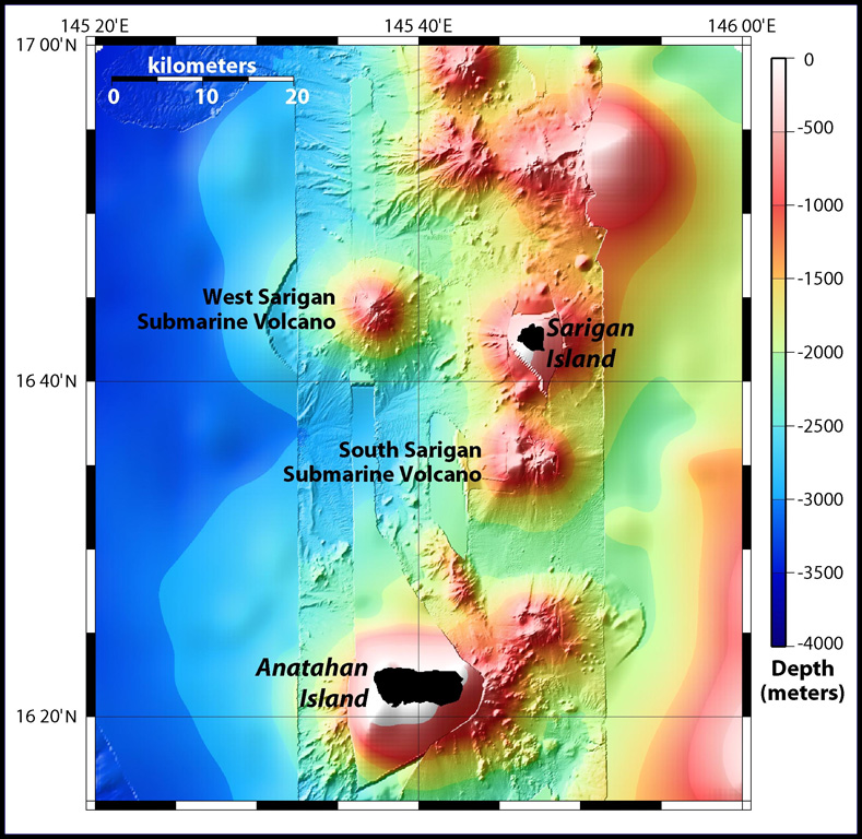
Sidescan sonar imagery taken in 2003 shows South Sarigan seamount rising to within about 184 m of the ocean surface 12 km S of Sarigan Island. It was the site of an explosive submarine eruption in May 2010 that sent a plume of ash and steam to 12 km altitude. The seamount has an irregular summit with multiple peaks, including a possibly young cone at about 350 m depth, and flank morphology suggests it is frequently active.
Sidescan sonar imagery taken in 2003 shows South Sarigan seamount rising to within about 184 m of the ocean surface 12 km S of Sarigan Island. It was the site of an explosive submarine eruption in May 2010 that sent a plume of ash and steam to 12 km altitude. The seamount has an irregular summit with multiple peaks, including a possibly young cone at about 350 m depth, and flank morphology suggests it is frequently active. · 写真: Map courtesy Bill Embley and William Chadwick (NOAA: http://oceanexplorer.noaa.gov/explorations/03fire/logs/feb17/feb17.html)
タイプ
成層火山
国
アメリカ合衆国
地域
北西太平洋 / Mariana Volcanic Arc
標高
184m (海底)
座標
16.580, 145.780
最終噴火
2010年
テクトニクス環境
沈み込み帯 / 地殻の厚さ不明
火山地形
複成火山
主要岩石
データなし
地質学的概要

South Sarigan seamount, rising to within about 184 m of the ocean surface 12 km S of Sarigan Island, was the site of a short explosive submarine eruption in May 2010 that produced a plume of ash and steam to 12 km altitude. Sidescan sonar imagery taken in 2003 shows an irregular summit with multiple peaks, including a possibly young cone at about 350 m depth, and flank morphology suggests it is a frequently active volcano.

噴火履歴

1件の記録用語集
概要 (VEI時系列)
バーをクリックすると個別の噴火が表示されます · 矢印キーで棒を移動、Enterで表示
2010~2010 · 1件 · 最大 VEI 320102010201120112011

詳細タイムライン

  1. 2010年VEI 3観測記録
    2010-05-27 ~ 2010-05-29
    Northern summit cone, 184 m below sea level

近くの火山

外部リンク

⚠ 参考情報です。緊急対応には使用しないでください。