本文へスキップ
地図に戻る
比較地図で見る

アメリカ合衆国 · 成層火山

Ruby

タイプ
成層火山
標高
174m (海底)
最終噴火
2023年
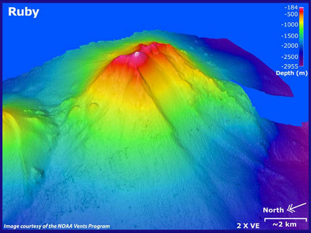
Ruby submarine volcano in the southern Mariana arc is seen in this bathymetric data looking from the NW with 2x vertical exaggeration. Depths in this image range from 184 to 2,955 m, and it rises to within 230 m of the ocean surface NW of Saipan. There was an eruption detected in 1966 by sonar signals. In 1995 submarine explosions were heard, accompanied by a fish kill, sulfurous odors, bubbling water, and the detection of volcanic tremor.
Ruby submarine volcano in the southern Mariana arc is seen in this bathymetric data looking from the NW with 2x vertical exaggeration. Depths in this image range from 184 to 2,955 m, and it rises to within 230 m of the ocean surface NW of Saipan. There was an eruption detected in 1966 by sonar signals. In 1995 submarine explosions were heard, accompanied by a fish kill, sulfurous odors, bubbling water, and the detection of volcanic tremor. · 写真: Image courtesy of Susan Merle (Oregon State University/NOAA Vents Program).
タイプ
成層火山
国
アメリカ合衆国
地域
北西太平洋 / Mariana Volcanic Arc
標高
174m (海底)
座標
15.605, 145.572
最終噴火
2023年
テクトニクス環境
沈み込み帯 / 地殻の厚さ不明
火山地形
複成火山
主要岩石
玄武岩 / ピクライト質玄武岩
地質学的概要

Ruby is a basaltic submarine volcano that rises to within about 200 m of the ocean surface near the southern end of the Mariana arc NW of Saipan. An eruption was detected in 1966 by sonar signals (Norris and Johnson, 1969). Submarine explosions were heard in 1995, accompanied by a fish kill, sulfurous odors, bubbling water, and the detection of volcanic tremor.

噴火履歴

3件の記録用語集
概要 (VEI時系列)
バーをクリックすると個別の噴火が表示されます · 矢印キーで棒を移動、Enterで表示
1966~1972 · 1件 · 最大 VEI 11995~2000 · 1件 · 最大 VEI 12017~2023 · 1件 · 最大 VEI 119661977199520062017

詳細タイムライン

  1. 2023年VEI 1観測記録
    2023-09-14 ~ 2023-09-15
  2. 1995年VEI 1観測記録
    1995-10-11 ~ 1995-10-25
  3. 1966年VEI 1観測記録
    1966-04-21 ~ 1966-05-16

近くの火山

外部リンク

⚠ 参考情報です。緊急対応には使用しないでください。