本文へスキップ
地図に戻る
比較地図で見る

イエメン · 火山原

Haylan, Jabal

タイプ
火山原
標高
1550m
最終噴火
-1200年
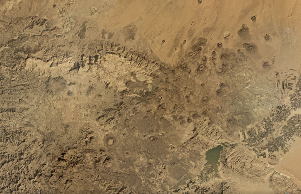
The Jabal Haylan volcanic field comprises scoria cones and tuff rings and associated lava flows across a 75-km-long area, with a portion of the field shown in this Planet Labs satellite image monthly mosaic (N is at the top; this image is approximately 52 km across). The chain crosses a NW-SE-trending fault that with visible offset in this image. Many of the cones and rings have experienced flank collapse, rafting, or erosion, leaving amphitheater-shaped craters. Some tuff rings appear to have lava domes that have formed within the crater.
The Jabal Haylan volcanic field comprises scoria cones and tuff rings and associated lava flows across a 75-km-long area, with a portion of the field shown in this Planet Labs satellite image monthly mosaic (N is at the top; this image is approximately 52 km across). The chain crosses a NW-SE-trending fault that with visible offset in this image. Many of the cones and rings have experienced flank collapse, rafting, or erosion, leaving amphitheater-shaped craters. Some tuff rings appear to have lava domes that have formed within the crater. · 写真: Satellite image courtesy of Planet Labs Inc., 2019 (https://www.planet.com/).
タイプ
火山原
国
イエメン
地域
アラビア・中央アジア / Southwest Arabia Volcanic Province
標高
1550m
座標
15.400, 45.100
最終噴火
-1200年
テクトニクス環境
プレート内部 / 大陸地殻 (> 25 km)
火山地形
火山群
主要岩石
玄武岩 / ピクライト質玄武岩

地質学的概要

英語の原文

The Jabal Haylan area contains a 75-km-long chain of tuff cones and associated olivine basaltic lava flows in eastern Yemen.

出典:Global Volcanism Program, Smithsonian Institution(抜粋) · GVP で全文を読む →

噴火履歴

1件の記録用語集

記録の概要

確認された噴火
1件
不確実な噴火
0件
確認された記録の範囲
紀元前 1200年 ~ 紀元前 1200年
確認された最大の噴火
VEI 0(紀元前 1200年)
1900年以降の確認された噴火
0件
概要 (VEI時系列)
バーをクリックすると個別の噴火が表示されます · 矢印キーで棒を移動、Enterで表示
紀元前 1200~紀元前 1200 · 1件 · 最大 VEI 0紀元前 1200紀元前 1200紀元前 1199紀元前 1199紀元前 1199

詳細タイムライン

  1. 紀元前 1200年VEI 0地質学的推定
    紀元前 1200 ~ 終了日不明
    West of Sirwan

近くの火山

外部リンク

⚠ 参考情報です。緊急対応には使用しないでください。